Harvesting Data for Agriculture
New technology for better drone-based data collection and analysis is helping turn North Carolina’s agricultural research stations into farms of the future, and an N.C. Plant Sciences Initiative team is intent on delivering even more solutions to help farmers put data to work.

A technological revolution is taking flight at North Carolina’s agricultural research stations.
At the Sandhills Research Station in Jackson Spring, a drone emerges from a weatherproof box, ascends to a pre-programmed altitude and flies over acres of fields, collecting images that will push forward solutions to make agriculture more data-driven, profitable and sustainable.
There’s no pilot on-site holding a remote control. Instead, the mission is initiated from a computer miles away at NC State University’s campus in Raleigh.
The autonomous drone flight is the next phase of a project called AIRS, short for Automating Intelligence from Research Stations.
In December 2025, the three-year-old project released a software suite that enables researchers to tap into data and images collected weekly from drone-mounted cameras at the Sandhills station and the Central Crops Research Station in Clayton.

While the project team’s efforts have focused on making it easier and more efficient for researchers to get reliable, comparable data from their field experiments, leader Chris Reberg-Horton calls the software release “just the tip of the iceberg” — a starting point toward creating an archive of data from each one of the state’s 18 agricultural research stations, every week, to answer both current and future research questions.
“We hope to move into data collection via ground-based robots and tractor-based imaging systems for all types of crops,” says Reberg-Horton, a professor of crop and soil sciences who directs the N.C. Plant Sciences Initiative’s resilient agriculture platform.
From there, the vision gets even broader.
“We can make intelligence out of that data in real time that then helps a grower make decisions,” he says. “We want to be able to tell them, for example, ‘You have an outbreak of this disease, and it looks like it’s strongest in these fields and in these particular parts of those fields.’”
Real-Time Data for Ag Solutions Now — and in the Future
To realize that vision, Reberg-Horton and others involved in the AIRS project started meeting weekly in late 2022, shortly after NC State’s Plant Sciences Building opened. Funding came from the N.C. PSI, the university’s Plant Breeding Consortium, the N.C. Agricultural Research Service and the U.S. Department of Agriculture.
The team includes a diverse group of agricultural scientists, computing and geospatial specialists and engineers from the university and the USDA’s Agricultural Research Service. Most are affiliated with the N.C. PSI.
Team members from NC State are Jevon Smith, research computing manager for the College of Agriculture and Life Sciences; Rob Austin, a research specialist in remote sensing and geospatial analysis; Frank Bai, who engineers new technology for precision and digital agriculture; and Joe Gage, who studies the links between plant genetics and traits to inform the development of resilient, productive crop varieties.
Those from the USDA-ARS are computational biologist Amanda Hulse-Kemp, digital agriculture director Steven Mirsky and soybean researcher Anna Locke.
While their expertise varies, the team members are united by a shared idea that streamlining data collection from research is key to making farming more precise, productive and profitable.
Agricultural research stations seemed like the best place to start, Reberg-Horton says. The stations serve as living laboratories, allowing agricultural scientists from NC State, N.C. A&T State University and their USDA partners to test solutions for a wide variety of crops, under real-world conditions that range from the steep, cold mountains of the west to the humid coastal plains of the east.
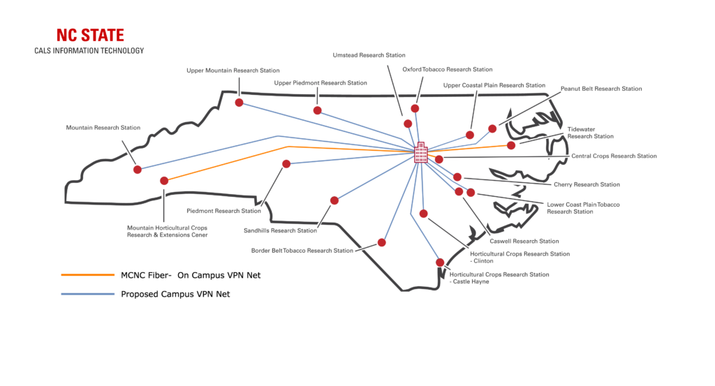
These experiments are critical, he says, for helping ensure that the state’s farmers have access to hardier, more resilient crop varieties and data-driven strategies that enable them to deliver a safe, affordable and abundant supply of food and fiber that a growing population needs.
High-Throughput Phenotyping: Accelerating Discovery
Joe Gage, an assistant professor in the Department of Crop and Soil Sciences, is among the hundreds of researchers, faculty members and students who depend on the stations.
Plant breeders are the first beneficiaries of his efforts to understand the links between genomic and phenomic data, and they were among the first introduced to the AIRS software.
As Gage explains, traditional plant evaluation — or phenotyping — requires researchers and their students to manually walk through miles of plots, measuring plant height or rating disease severity by sight or with handheld tools.

The type of high-throughput phenotyping that drones can support are transforming this process, Gage says.
“Any given sort of plant breeding program may be running acres and acres worth of plots that need to be measured. In the past we’ve done that all by hand, and it takes time for somebody to manually, physically measure a characteristic on every single plant,” he explains.
Drones can survey those same acres in a fraction of the time, capturing data that the human eye might miss, such as infrared reflectance that indicates plant stress.
This efficiency doesn’t just save labor; it unlocks a longitudinal dimension of research by allowing weekly flights to track plant growth over time, he adds.
“If you wanted to know how a corn plant grows over the course of the season and fit a growth curve to it, you would need to go out with a huge yardstick and measure it every week. Imagine the time it takes to do that across hundreds or thousands of plants,” Gage observes. “With drones, you just need the time to fly once a week.”
From Fragmented Efforts to Standardized Intelligence
While the switch from traditional methods to drones might sound simple, getting systems set up that would enable regular drone flights across the stations was anything but.
Doing it right required new operational frameworks and the infrastructure to get data from remote stations to the university campus.
When the AIRS project started, ag researchers, including geospatial specialist Rob Austin, had been flying drones for years at the research stations and over trials at private farms.
Everyone was on their own little island, all solving the same problems from scratch.
Most efforts were decentralized and fragmented, Austin recalls. “Everyone was on their own little island, all solving the same problems from scratch.”
Each researcher was having to figure out what equipment they needed to get the type of data their study required. They also needed to learn to use the equipment and successfully navigate complex federal aviation regulations.
Then they had to come up with ways of working around the vagaries of nature, like passing puffy clouds that can cast shadows and skew the data.
While researchers got better over time at gathering data, there wasn’t a concerted effort to make sure that it was reliable and comparable enough to be shared, combined and understood by other scientists.
“We really needed to develop a pipeline and a framework at the college level that would make the data comparable and accessible,” Austin says. “Standardizing equipment and the data that was being collected was an important part of this project.”
The team also recognized the need to create a structured way to collect, transfer and analyze the data, and then get it back to the researchers, he adds.
Building the Digital Backbone: Fiber and Computing
That’s where research computing specialist Jevon Smith came in.
Recognizing that the infrastructure beneath the soil would need to be just as important as the technology in the air, Smith spent frigid December weekends digging trenches for fiber optic cables that would support transferring massive amounts of data collected by drones, cellphones, sensors and other technologies from the research stations and get it to researchers in ways that aided their work.
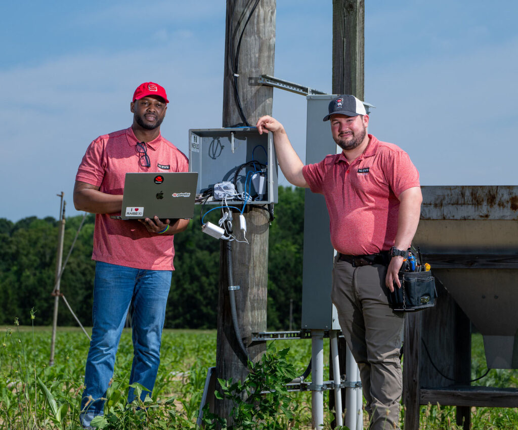
Today, not all of North Carolina’s research stations have the capacity to support efforts like AIRS. The Sandhills station became the pilot project’s first location because it had a solid connection and an eager partner in superintendent Jeremy Martin.
Working with the university’s Office of Information Technology, Smith and his CALS IT counterparts developed a system that would enable staff members at the Sandhills station, and later the Central Crops Research Station in Clayton, to upload drone-collected files with terabytes of data. A specialized app then transfers them to the university campus at midnight.
“That automates a cascade,” Smith explains. “Those files get transferred over to our big compute cluster. They get processed and then written back to data products for researchers.”
The “data products” Smith refers to are precise two-dimensional maps known as orthomosaics, rich three-dimensional models known as point clouds and analytical visualizations known as heat maps.

“Heat maps use color gradients to convey information. Say, green is good, yellow is OK and red is a problem, and it’ll tell you exactly to the meter where your problem is,” Smith explains.
Autonomous Future: Drone in a Box

While piloted drones were a significant first step, Austin says that the AIRS team quickly realized limitations.
The weather windows for drone flights are narrow, and research station personnel often tasked with piloting drones are at their busiest with other work during the most critical times for data collection, including planting and harvest.
The solution to such challenges could lie in the autonomous drone-in-a-box docking system that Frank Bai, of the Department of Biological and Agricultural Engineering, is testing with USDA-ARS soybean breeder Benjamin Fallen.

“Research teams often need to travel a few hours to research stations to collect the data. I used to have to stay overnight to collect data in the late afternoon and early morning,” Bai recalls.
With a rare FAA waiver for what are called “beyond visual line of sight” operations, Bai’s team can now operate drones remotely from NC State’s campus.
“We have the drone at the site, and some of us can just operate the drone from Raleigh,” Bai says. “That will save us a lot of money, because everything’s automatic.”
This technology currently supports research into drought-tolerant soybeans, providing high-frequency data — including hourly flights on selected days — to precisely measure water efficiency.
Helping Researchers Help Growers
As Bai and Fallen continue their research, Reberg-Horton, Smith and others are pushing to ensure that the ground broken by the AIRS team will be seeded by other projects to advance data collection and analysis from all of the state’s research stations.
That would allow farmers producing all crops in all of the state’s geographic regions to benefit, Smith says.
“The high-speed fiber connections, graphics processing units, supercomputers and partnerships with companies such as NVIDIA, AWS, Del, and Lenovo have been enablers of these research capabilities,” he adds.
Smith sees the Tidewater Research Station in Plymouth as a likely site for expansion of these efforts, given its solid internet connections.
And Reberg-Horton thinks that, along with further digitization of North Carolina’s research stations, will be a leap forward, putting North Carolina at the forefront of agricultural innovation.
As the AIRS team’s tools become available to researchers, allowing them to survey larger areas faster than ever before, Reberg-Horton wants to see new projects take shape.
Ideally, those projects would include the development of AIRS-like tools and automated AI-enabled systems that are finetuned for growers and tailored to make their operations more profitable and sustainable.
We can derive intelligence from those images to help growers make real-time decisions that have a positive impact.
Reberg-Horton sees autonomous drones, coupled with robotic rovers and other devices, coming together to gather data and automate farm tasks. That, he says, would make farming a more precise endeavor and help alleviate a persistent labor shortage that many farmers see as their top challenge.
“The day is coming when farms will have images of what’s happening all across their fields coming in from their combines, their planters, their tractors, from robots working the fields and from drones overhead,” he says. “Our research stations can be testbeds for making that happen.”
“The beauty of that is we can derive intelligence from those images to help growers make real-time decisions that have a positive impact for them and, ultimately, for consumers.”